Log jams can be beneficial in natural stream settings by creating pools and diversions, enhancing retention of organic matter and sediment, reducing sedimentation in receiving reservoirs, and providing diverse habitat for aquatic organisms[1]. However, frequent debris accumulations can overwhelm sluggish channels and overload flood control reservoirs.
Studying log jams
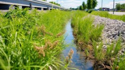
A recent study examined log jams and controlling factors on the Elm Fork of the Trinity River between two lakes in Denton County, Texas (Figure 1). The Elm Fork’s gradient is shallow, approximately 1.6 ft/mi (0.3 m/km) between the outfall at Ray Roberts Lake (upstream of the study area) and its mouth at Lewisville Lake. An earthen dam completed in 1955 impounds Lewisville Lake, which controls flooding, provides water to local cities, and supports fishing and boating. The lake fluctuates widely around a conservation pool of 522.0 ft (159.15 m) above mean sea level due to large variations in annual rainfall and runoff.
Creeks and releases from Ray Roberts Lake, located approximately 12 miles (19 km) upstream of the study area, supply water to the Elm Fork (Figure 1). Completed in 1987, Ray Roberts Lake provides similar, multi-use purposes as Lewisville Lake. Texas Parks and Wildlife manages the wooded greenbelt along the Elm Fork. Hackberry (Celtis occidentalis and C. laevigata), cedar elm (Ulmus crassifolia), and green ash (Fraxinus pennsylvanica) dominate the riparian hardwood forest[2].

Looking at the causes of the log jams
Both natural processes and human activity contribute to fallen trees in the Elm Fork corridor. For example, heavy winds can topple trees, and heavy rainfall adds weight to trees, saturates soil and destabilizes root foundations. Extended drought weakens trees in the study area, making them vulnerable to falling, and wood-boring beetles, including emerald ash borer (Agrilus planipennis), further damage trees in the area.
Ten satellite images from Google Earth (Google Corporation, Mountain View, California) were studied to identify log jams over a seven-year period (Figure 1). Five locations on the Elm Fork in the study area were jammed on at least four of the ten observation dates, and 16 additional locations were jammed on one to three dates. Log jams became more common later in the data record.
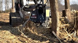
A large log jam, which accumulated near the Highway 380 bridge over several years, was eventually cleared with heavy equipment in the summer of 2020. This project, managed by the Texas Department of Transportation, was undertaken to address flooding concerns of upstream landowners and maintain the bridge's integrity. The log jam grew to approximately 30 meters wide and 150 meters long. It became a contiguous mass of logs, brush, debris and sediment. Decomposing wood and sediment formed a substrate for grassy vegetation. Water backed up behind the log jam, further reducing an already low gradient on the Elm Fork.

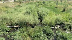
Recent field work documented an ongoing log jam upstream of the Highway 380 bridge (Figure 2). Large fallen logs, and live trees adapted to wet conditions and anchored the mass, while smaller limbs, debris, and sediment filled in spaces between logs. Past log jams at this location have contributed to floods in a nearby parking lot used to access the greenbelt for recreation.
Figure 3 illustrates periodic high water moving through the Elm Fork, at a gaging station near the Ray Roberts spillway. Normal (base) stream level at this gage is approximately 8 feet (2.4 meters). At this low stage, water moves very slowly through downstream reaches of the channel. However, heavy discharge to the spillway maintains higher stream levels over extended periods, ranging from days to months. Occasionally, water levels at this gage exceed 20 feet (6 meters). High-water pulses, more prominent in spring, dislodge trees and move them downstream, eventually depositing large tree trunks that anchor log jams.
For example, the high-water period beginning around February 2015 and lasting for approximately 18 months likely contributed to uprooting and movement of logs accumulating in the large pile-up near Highway 380 that was manually cleared in 2020. Additionally, September 2018 to July 2019 and October 2019 to October 2020 were extended periods of above-normal stream flow. Several log jams, designated “e” to “g” in Figure 1, occurred during or shortly after these time intervals. Similarly, high water levels in the spring of 2021, 2022 and 2023 likely contributed to fallen logs and subsequent movement, resulting in log jams observed on dates “h” to “j” (Figure 1).
The monthly Palmer Drought Index documents extended wet and dry periods in the study area. Typically, these wet and dry cycles last for less than a year, but some last for more than three years. Drought tends to weaken trees, whereas wet conditions saturate and destabilize soils. Operating together, prolonged wet and dry cycles promote treefall. For example, a dry period from 2012 to 2014, followed by relatively wet conditions in subsequent years, likely contributed to the previously mentioned log jam at Highway 380.
Further problematic, emerald ash borer (Agrilus planipennis) was confirmed in north-central Texas as early as November 2019 and in Denton County as early as May 2020[3].
In February 2024, damage was spotted from emerald ash borer in two large green ash trees near Lewisville Lake, in the east-central part of the vicinity map (Figure 1). Additionally, numerous trees damaged by wood-boring beetles were spotted on the banks and floodplain of the Elm Fork, at a greenbelt access about midway between Ray Roberts Lake and the northern edge of the study area.
Emerald ash borer likely moved into the study area from locations to the east. The beetle was spotted in April 2016 in Harrison County in northeastern Texas[3]. Emerald ash borer infestations spread up to 12 miles (19 kilometers) a year naturally; however, transporting infested firewood and other wood products causes more rapid spread[3].
Before the two dams were built, larger flood waves moved through the Elm Fork and likely uprooted trees, but more effectively moved them, resulting in occasional log jams or wood deposition on the floodplain. However, the Elm Fork now lacks energy because Lewisville Lake raised its base level, thereby reducing its gradient. Moreover, Ray Roberts Lake attenuates large flood waves, replacing them with more subdued high-water pulses over extended periods of time. These subdued pulses have uprooting capability, but only modest flushing and transport capability.
Conclusion
The system lacks energy to flush debris naturally and thus requires periodic human intervention to prevent wood overloading. Just as reservoirs are maintained, riparian corridors connecting them should be managed, to avoid excessive backups that compromise the integrity of the modified hydrologic system. Monitoring tree health and debris load in the channel, selectively removing or stabilizing logs, and stabilizing rapidly eroding channel banks are examples of proactive measures that can help support the system.
Sources and references
[1] Gurnell, A.M., Gregory, K.J., Petts, G.E. 1995. The role of coarse woody debris in forest aquatic habitats: Implications for management. Aquatic Conservation: Marine and Freshwater Ecosystems, 5(2), 143-166.
[2] Barry, D., Kroll, A.J. 1997. Phytosociological Analysis of the Deep Bottom: A Bottomland Hardwood Forest in Denton, Texas. Institute of Applied Sciences, University of North Texas, Denton, Texas.
[3] TDA (Texas Department of Agriculture). 2024. Emerald Ash Borer. https://www.texasagriculture.gov/Regulatory-Programs/Plant-Quality/Pest-and-Disease-Alerts/Emerald-Ash-Borer#:~:text=and%20Tarrant%20Counties.-,04%2F23%2F2021.,United%20States%20Department%20of%20Agriculture.
NOAA (National Oceanic and Atmospheric Administration). 2024. Climate at a Glance: County Time Series. Available from: https://www.ncei.noaa.gov/access/monitoring/climate-at-a-glance/county/time-series
TAMFS (Texas A&M Forest Service). 2024. Tree-Killing Insect Confirmed in Denton and Bowie Counties. Available from: https://tfsweb.tamu.edu/content/article.aspx?id=30894
USGS (U.S. Geological Survey). 2024. Water-Year Summary for Site 08051135. Available from: https://waterdata.usgs.gov/nwis/wys_rpt/?site_no=08051135