One of the most expensive highway projects in Oregon’s history, the US Highway 20 Pioneer Mountain to Eddyville Project was first planned to simply reroute 10 miles of roadway along the state’s coastline — but ancient landslides and an erosion control failure complicated things.
The original 10-mile stretch of highway was narrow with sharp curves, rolling terrain, and very little safety shoulder clearance. The region wasn’t able to accommodate many interstate trucks: the Oregon Department of Transportation (ODOT) reported that each day more than 100 trucks had to travel significantly out of their way through other highways to reach their destinations.
Worse than traffic congestion and slow travel speeds, the stretch also contributed to serious safety issues. The portion was designated as a Highway Safety Corridor after it was found to have a crash rate 60 percent higher than similar state highways: between 1999 and 2014, the stretch was host to 374 crashes, 16 fatalities, and 271 injuries.
Planning the Work

ODOT and the design-build contractor worked together to create a plan for the project. The reroute would eliminate several sharp turns in the road, with a 5.5-mile stretch of new roadway designed to pass over valleys, requiring the construction of at least 10 new bridges. The roadways would also receive six to eight feet of safety clearance shoulders on either side, along with several miles of two-lane-wide roads and passing lanes.
The area around the Yaguina River, surrounding the original route, was sensitive and home to several endangered fish. The new alignment was designed to intentionally pull away from these habitats to reduce any potential impacts on water quality.
A First Attempt
Construction began in 2005 for a contract of $140 million, estimated to finish in 2009. However, the project would be host to several major challenges: the location was remote, with deep valleys and unpredictable landslides.

The area received as much as 100 inches of rainfall each year, and heavy winter rains meant that, annually, only about 120 days were appropriate for this type of construction.
“This is basically a temperate rainforest,” continues Marshall, “Even though I was there in the driest summer in recorded history, there was still water seeping out of the seams between the rock strata.”
With all these challenges in place, erosion control was a critical factor of the project.
Ancient Landslides
As the site was being cleared and several bridges’ foundations built, construction hit an unexpected problem: several landslides had occurred along the new road placement. ODOT and the contractor agreed to put construction on hold to investigate the issue.
They discovered that the area’s geology had a long history of ancient landslides and that the proposed bridges had been founded on active landslide areas.
The contractor offered two geotechnical construction methods to tackle the problem: buttresses and shear keys at the bottoms of the slopes to hold the soil in place. These proposed methods would add over 700,000 cubic yards of earthwork and $46 million to the overall project cost.
Ultimately, however, these methods did not work. In 2010, the contractor reported that the buttresses and shear keys failed to protect the project from landslides: several columns on two bridges had already become slanted. In 2011, it was discovered that one other bridge’s support sat on a slope that was moving, and that three other bridges’ foundations were in question.
“You see these gigantic concrete columns at the bottom of a canyon look like the ruins of Angkor Wat,” Marshall says. “And, as that was happening, the contractor had never really done work in Oregon before — and so the first thing [they] wanted to do was log it and market the timber. Well, as an erosion and sediment control specialist knows, the last thing you want is wholesale soil exposure.”
In 2006, at the end of a short work season, the contractor had cleared 160 acres of forest. The contractor left the exposed, unprotected hillsides without adequate erosion control — and the winter rains that year caused large amounts of sediment to flow into local creeks and streams. By the end of the rainy season, the Oregon Department of Environmental Quality (DEQ) found 41 water pollution violations.
“The erosion was catastrophic,” Marshall says. “The waters became chocolate milk, and the sediment accumulated on the river bottom to a depth of about shoulder deep: an environmental specialist put his arm into the sediment, and it went up to his shoulder. It was as bad as you can do with erosion and sediment control.”
Ultimately, the DEQ fined the design-builder $240,000, and ODOT $90,000.
“It compromised ODOT’s reputation,” continues Marshall. “And, you know, that’s something that’s hard to earn and easy to lose.”
Taking Over the Project

ODOT considered various options, including abandoning the unfinished project altogether. However, the department eventually decided to finish the project, keeping the original scope. Nearly 10 years after the project received a green light to begin work, the failure of the first attempt had caused the budget to soar as high as $365 million.
“We moved on to changing the design approach, which was [now] to fill up the canyons,” says Marshall.
To accommodate the area’s tenuous geology, ODOT’s geotechnical engineers were now driving the project.
ODOT quickly designed and contracted for the construction of Phase 1. This phase of the project included installing 70 miles of horizontal drains into the hillsides; installing blanket drains, which moved water away from slopes by providing an outlet for subsurface water; and demolishing four bridges, which sat in varying stages of completion.
In addition, the installation of hundreds of ground monitoring sensors helped ODOT take an observational approach to its project design: the instruments would help verify site conditions, allowing engineers to adjust their designs between phases.
By 2013, ODOT had designed and contracted for the construction of Phase 2, which included the construction of 29 more miles of horizontal drains, 3,216 feet of culvert to replace bridges, test fills to estimate the effects of loading, and the production and placement of 600,000 tons of rock.
In 2015, ODOT had designed and contracted for Phase 3, to construct another 12 miles of horizontal drains, several rock buttresses, and 415 ground anchors — while removing 130,000 cubic yards of earth to make room for a mitigation site for fish and wildlife habitats.
An additional 2.5 of horizontal drains, a large culvert under the highway to function as a wildlife crossing, and a high-water refuge for small fish were contracted in 2017.
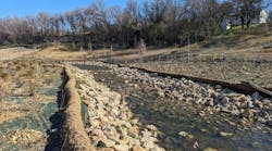
Upon completion, the project had employed over 113 miles of horizontal drains, blanket drains, trench drains, slope ditches, and under drains — as well as hundreds of check dams to reduce flow.

While the department originally had plans to use a mix of native plants for exposed slopes around the roadway, it eventually chose to use ryegrass with straw wattles every 20 feet and geogrids every 10 feet. But the site’s steep slopes — often as high as 100 to 300 feet — would prove a challenge for the ryegrass.
“The standard practice [is] to use rye grass, which germinates very quickly,” Marshall says. “But it’s not native, it’s very shallow-rooted, and, although it does provide protection against rain splash erosion into a slow runoff, it doesn’t do much for infiltration or to bind soil.”
As a result, pop-outs — shallow slides of land — occurred at several places along the project site. As a repair, the department rolled out several acres of erosion control matting and, for the project’s second phase, seeded the area with native vegetation and installed additional matting. These methods remained stable throughout the rest of construction.
“Simple is good, especially on a large scale like this,” says Marshall. “You don’t need to reinvent erosion and sediment control; things that work are already a matter of public domain. It’s a reasonable approach to use proven methods.”
After several landslides and an erosion catastrophe under the first design-build contract, ODOT was able to take control of the project using proven best management practices. Maintaining a strong dedication to erosion control, ODOT completed the Highway 20 project, including the construction of six miles of new roadway to replace the 10 mile corridor in the Fall of 2017, with no new DEQ water pollution violations.
“The most important thing,” Marshall says, “was that the agency was willing to commit resources to erosion and sediment control.” SW
Published in Stormwater magazine, May 2022.